About me
I am a PhD student in the Computer Vision Lab at UMass Amherst, advised by Prof. Subhransu Maji. My research explores the relationships between computer vision tasks, with a focus on multi-task and transfer learning, and developing robust embeddings for large-scale scientific applications. My primary application domain is environmental remote sensing, where I build models to analyze multispectral satellite imagery for hydrology.
Before my PhD, I was a graduate research assistant at the University of the Philippines working on 3D reconstruction under the supervision of Prof. Rowel Atienza, where I completed my M.S. in Electrical Engineering. I obtained my B.S. in Electronics and Communications Engineering from the same univeristy.
News
- 2026-05 Will be a Research Intern at Adobe this summer!
- 2026-03 Our paper on Operational near real time global riverine sediment flux estimates from space is accepted for publication to Geophysical Research Letters
- 2026-02 RealBirdID accepted to CVPR 2026!
- 2026-01 Our work with NASA on monitoring rivers was featured on the UMass website here
- 2026-01 Received the 2025 AGU Remote Sensing Student Award for RiverScope!
- 2025-12 Attending AGU’25! I’ll be giving two oral presentations on our latest work in remote sensing: RiverScope and WildSAT
- 2025-11 SuperRivolution accepted to WACV 2026!
- 2025-11 RiverScope accepted to AAAI 2026! I will also be giving an oral presentation at AAAI.
- 2025-06 WildSAT accepted to ICCV 2025! Also presenting it at the Computer Vision for Ecology workshop as a Spotlight talk
- 2025-03 Our paper on Improving Satellite Imagery Masking using Multi-task and Transfer Learning has been published at IEEE JSTARS
- 2025-01 Gave a talk at the University of the Philippines about “Computer Vision in the Wild”
- 2024-05 Passed PhD Portfolio with Distinction! (Awarded to select PhD students meeting a high standard of completion, voted by faculty)
- 2024-03 Task2Box paper accepted at CVPR 2024 as a Highlight (11.9% of accepted papers)!
- 2023-10 COSE paper presented in VIPriors at ICCV 2023
- 2022-09 Started PhD CS at University of Massachusetts Amherst
- 2020-06 REIN accepted (oral presentation) at CVPR 2020 workshop
- 2018-01 Started MS Electrical Engineering at University of the Philippines
Selected Publications
(* means equal contribution)
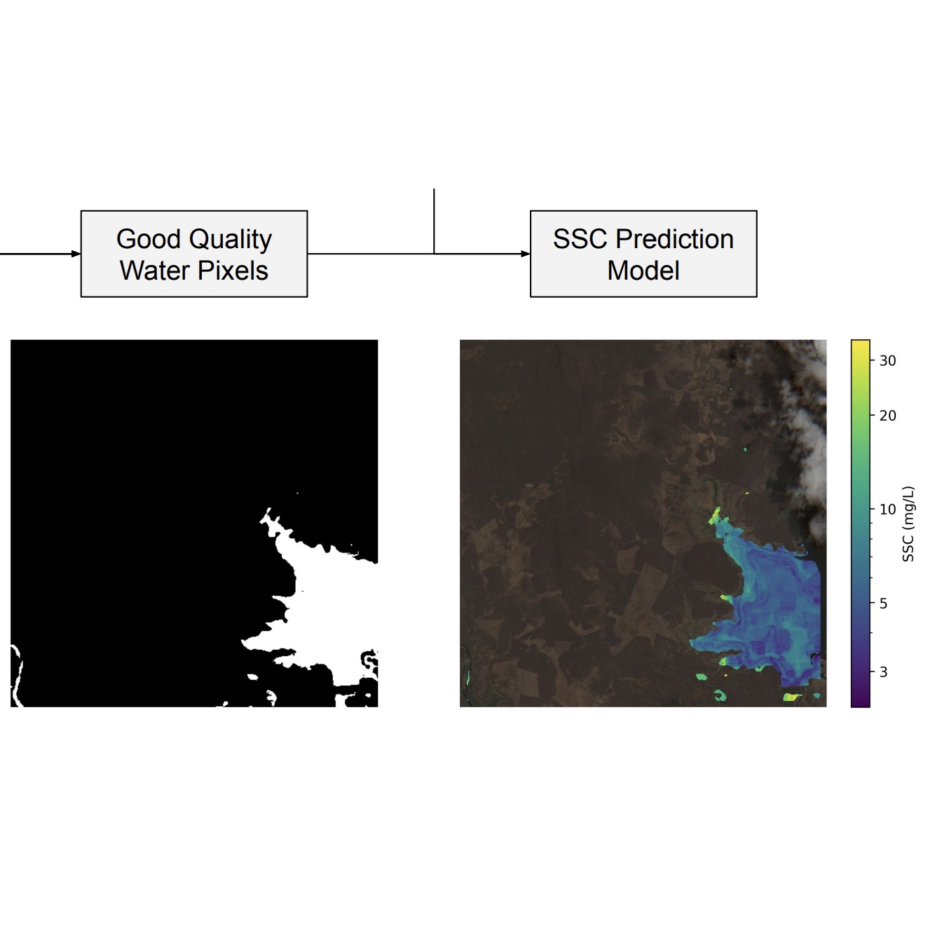
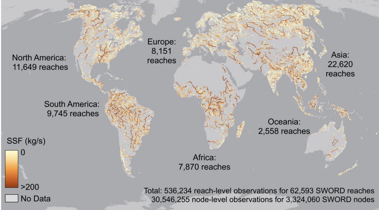 | Operational near real time global riverine sediment flux estimates from space Luisa Vieira Lucchese, Rangel Daroya, Travis T Simmons, Punwath Prum, Nikki E Tebaldi, Tamlin M Pavelsky, Subhransu Maji, John R Gardner, Colin Gleason Geophysical Research Letters 2026 GRL26 / Authorea We present global estimates of riverine sediment flux derived from an open-source suite of algorithms using the Harmonized Landsat Sentinel (HLS) and Surface Water and Ocean Topography (SWOT) satellite products. |
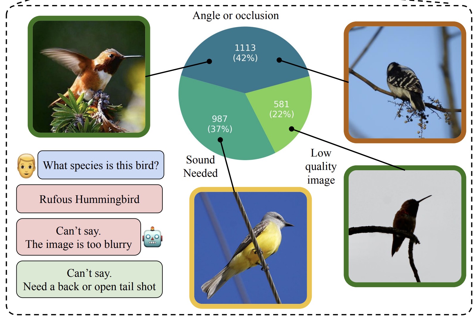 | RealBirdID: Benchmarking Bird Species Identification in the Era of MLLMs Logan Lawrence, Mustafa Chasmai, Rangel Daroya, Wuao Liu, Seoyun Jeong, Aaron Sun, Max Hamilton, Fabien Delattre, Oindrila Saha, Subhransu Maji, Grant Van Horn CVPR 2026 arXiv We propose the RealBirdID benchmark: given an image of a bird, a system should either answer with a species or abstain with a concrete, evidence-based rationale: "requires vocalization," "low quality image," or "view obstructed". |
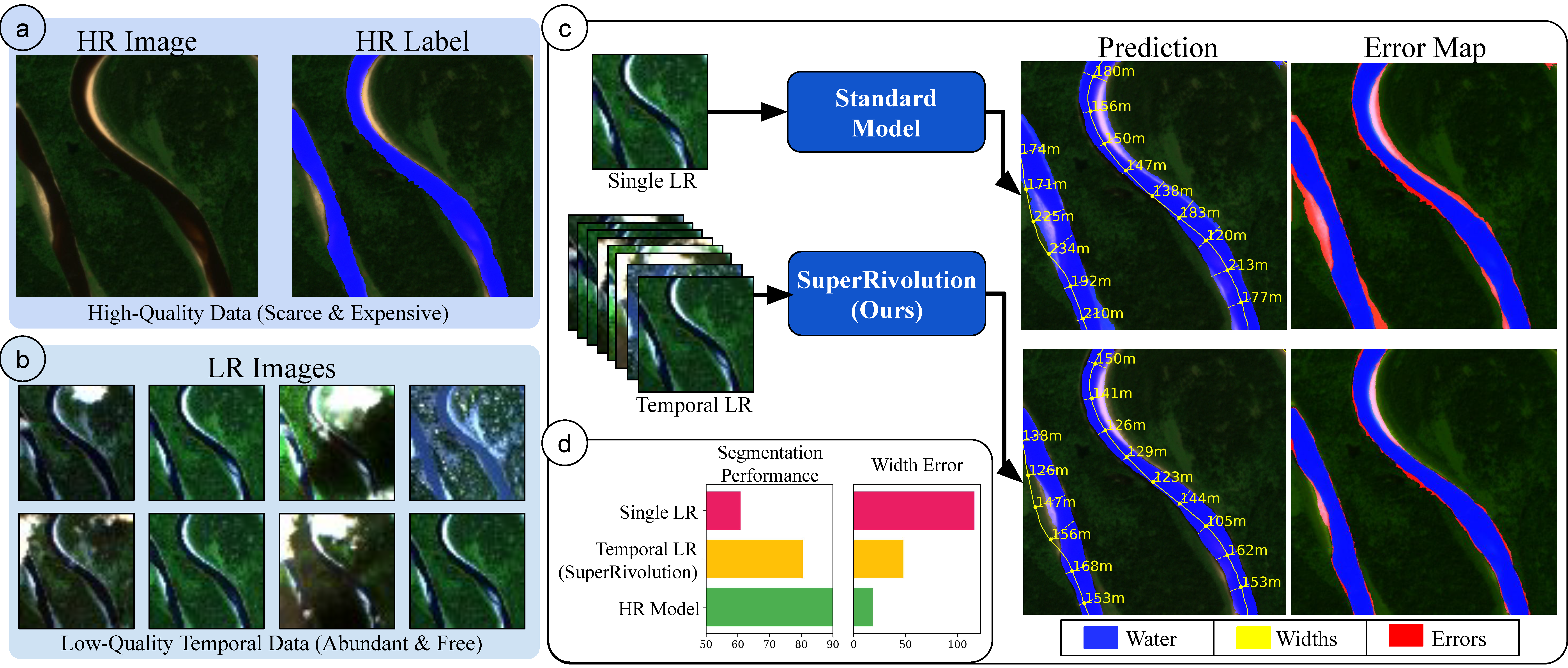 | SuperRivolution: Fine-Scale Rivers from Coarse Temporal Satellite Imagery Rangel Daroya, Subhransu Maji WACV 2026 WACV26 / arXiv We introduce a method and an accompanying dataset that leverages multiple low-resolution satellite imagery instead of expensive high-resolution imagery for fine-scale satellite image tasks such as river width estimation. |
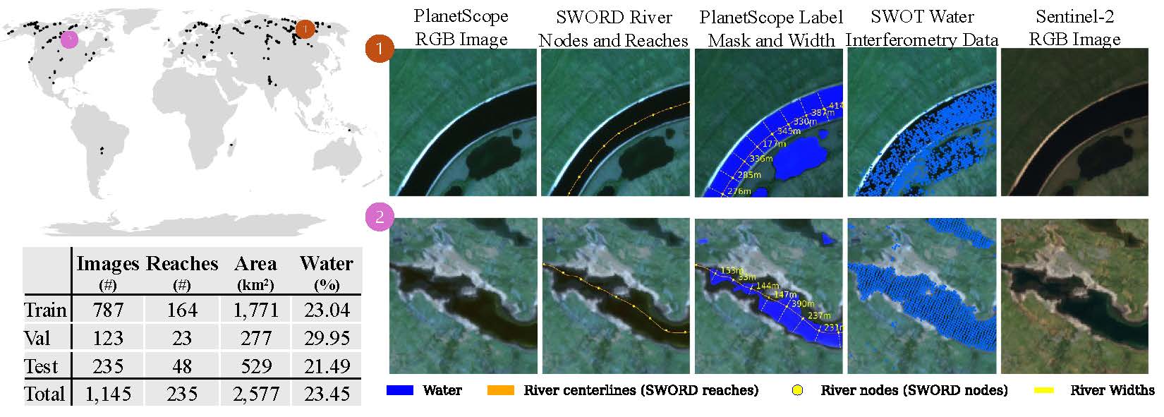 | RiverScope: High-Resolution River Masking Dataset Rangel Daroya, Taylor Rowley, Jonathan Flores, Elisa Friedmann, Fiona Bennitt, Heejin An, Travis Simmons, Marissa Jean Hughes, Camryn L Kluetmeier, Solomon Kica, J Daniel Vélez, Sarah E Esenther, Thomas E Howard, Yanqi Ye, Audrey Turcotte, Colin Gleason, Subhransu Maji AAAI 2026, AI for Social Impact (Oral Presentation) AGU 2025 (Remote Sensing Student Award) AAAI26 / arXiv We introduce a high-resolution river segmentation dataset that can be used for precise hydrology tasks such as river segmentation and river width estimation. |
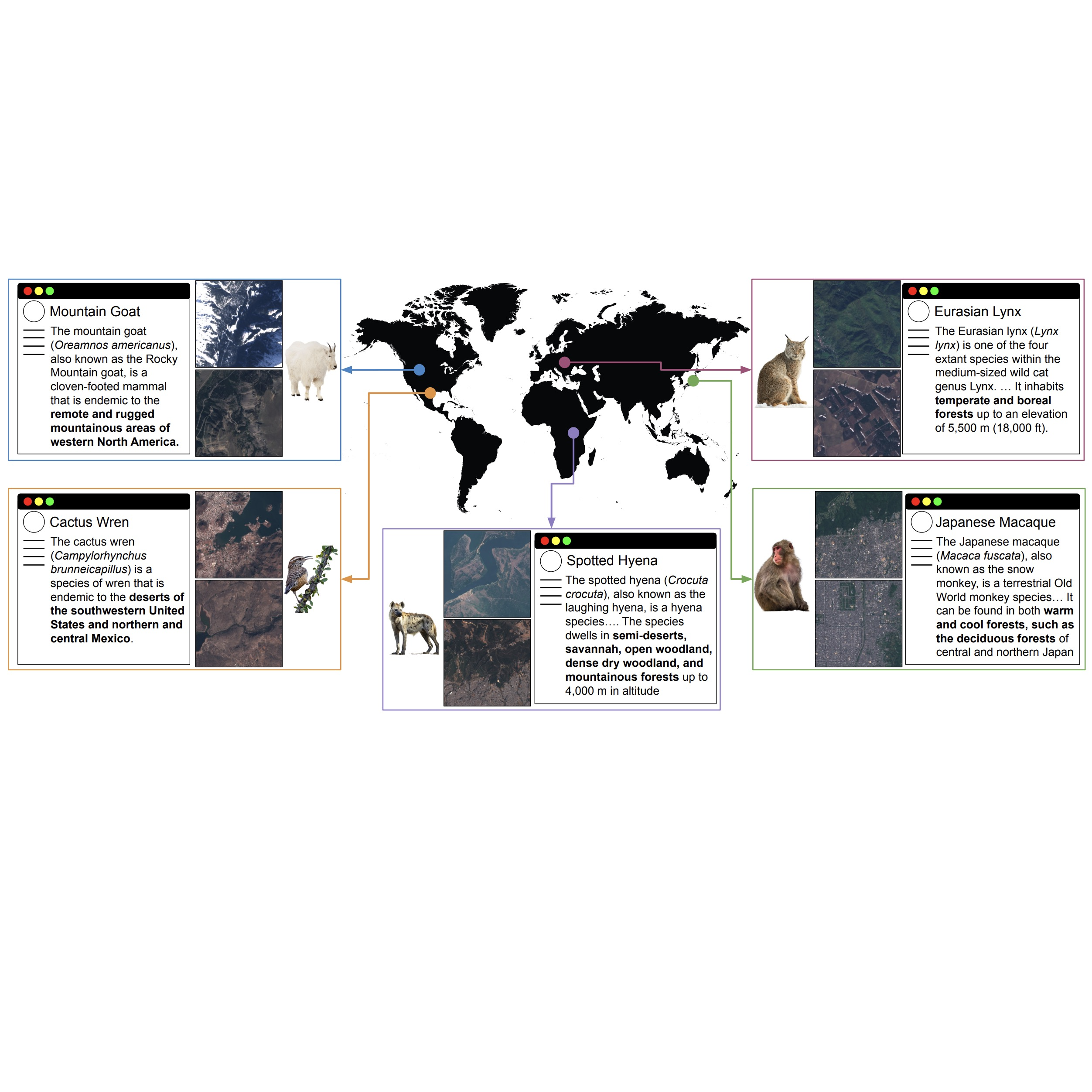 | WildSAT: Learning Satellite Image Representations from Wildlife Observations Rangel Daroya, Elijah Cole, Oisin Mac Aodha, Grant Van Horn, Subhransu Maji ICCV 2025 CV4Ecology Workshop @ ICCV 2025 (Spotlight Talk) ICCV25 / arXiv We show satellite image representations can be improved using wildlife observations due to information we can get from wildlife habitats |
 | Improving Satellite Imagery Masking using Multi-task and Transfer Learning Rangel Daroya, Luisa Vieira Lucchese, Travis Simmons, Punwath Prum, Tamlin Pavelsky, John Gardner, Colin J Gleason, Subhransu Maji IEEE Journal of Selected Topics in Applied Earth Observations and Remote Sensing 2025 JSTARS25 / arXiv We show a multi-task model for predicting water, cloud, cloud shadow, terain shadow, and snow/ice simultaneously from satellite images. |
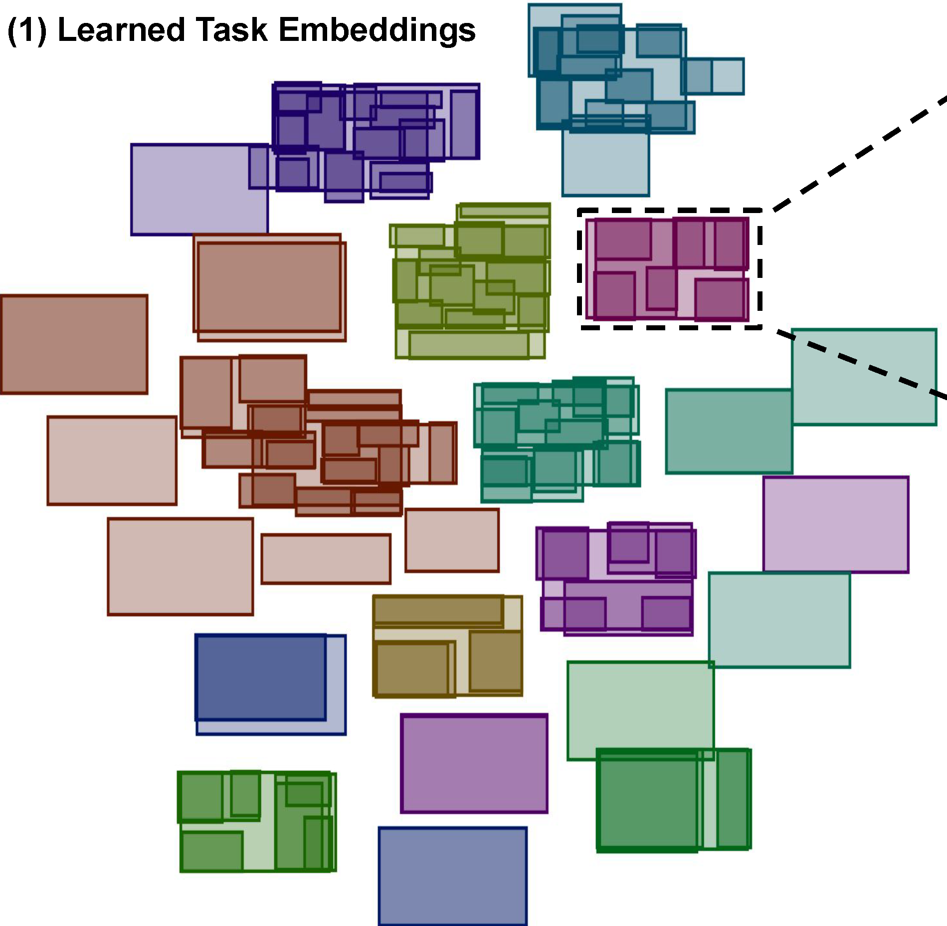 | Task2Box: Box Embeddings for Modeling Asymmetric Task Relationships Rangel Daroya, Aaron Sun, Subhransu Maji CVPR 2024 (Highlight: 11.9% of accepted papers) project page / CVPR24 / arXiv We present a method for modeling asymmetric relationships between vision tasks using box embeddings. |
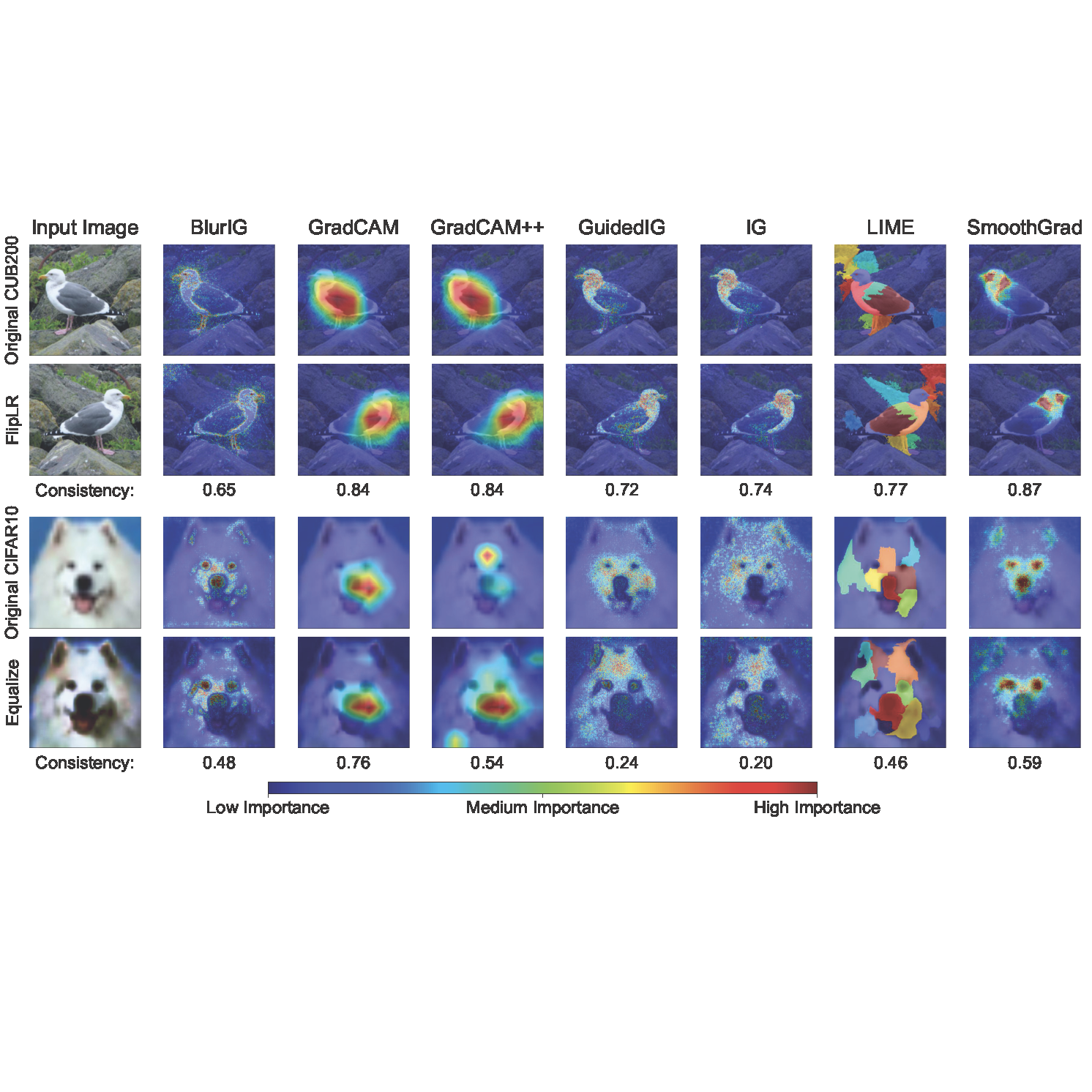 | COSE: A Consistency-Sensitivity Metric for Saliency on Image Classification Rangel Daroya*, Aaron Sun*, Subhransu Maji ICCVW 2023 project page / ICCVW23 / arXiv We propose metrics related to the consistency and sensitivity of saliency maps on image classification tasks to assess the performance of different explainable AI methods on a variety of models and datasets |
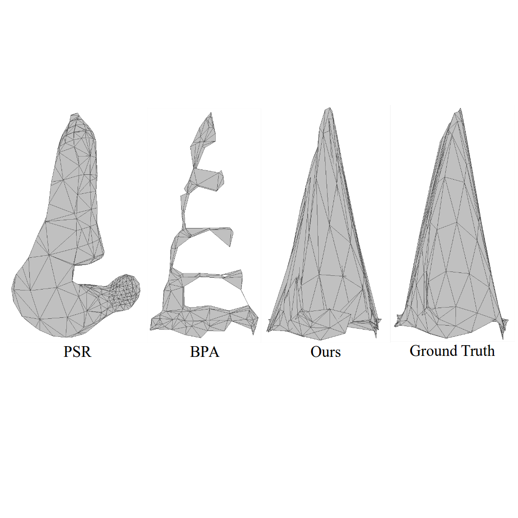 | REIN: Flexible mesh generation from point clouds Rangel Daroya, Rowel Atienza, Rhandley Cajote CVPRW 2020 CVPRW20 We present a method for generating a mesh from a sparse point cloud with an arbitrary number of points |